
What's The Difference Between 1D And 2D Hydraulic Modeling And How To Decide Between Them?
By Trevor English
Predicting floods and how these flows of water interact with topography and infrastructure has presented a menagerie of challenges for engineers of past and present. Like any force of nature, floods are dynamic events that encompass a series of interrelated factors that determine the resultant effects. Factors like topographical variance, soil permeability, precipitation intensity, existing stormwater controls, and plenty more. Hydraulic modelers thus must deal with these factors in modeling and predicting flooding events, usually through programs that run 1D and/or 2D models of water flow.
But what’s the difference?
Let’s walk through what 1D and 2D hydraulic modeling is, the pros and cons of each, and move through a sample workflow of how to decide between them.
What are 1D and 2D models?
Put simply, 1-Dimensional, or 1D, models water flow along an alignment or path, in one direction, like a channel or river, while 2-Dimensional, or 2D, models water flowing over an entire area or floodplain, incorporating flow in multiple directions. But let’s dig into each of these modeling types a little deeper.
1D models utilize 1D equations of flow in channels. Called 1D Saint-Venant equations (aka shallow water equations), the resultant computations deliver cross-sectional average water surface elevation along with velocity for given cross sections. Equations like the continuity equation and the momentum equation all factor in here. 1D hydraulic modeling software makes this process simpler, though, as engineers can simply put in their known constraints and variables, along with their site data, and the software will work through these equations to deliver resultant values. The name 1D comes from the fact that the resultant output of these calculations is a single water level, velocity, and flow rate for each node in the model. So then, how is 2D hydraulic modeling different?
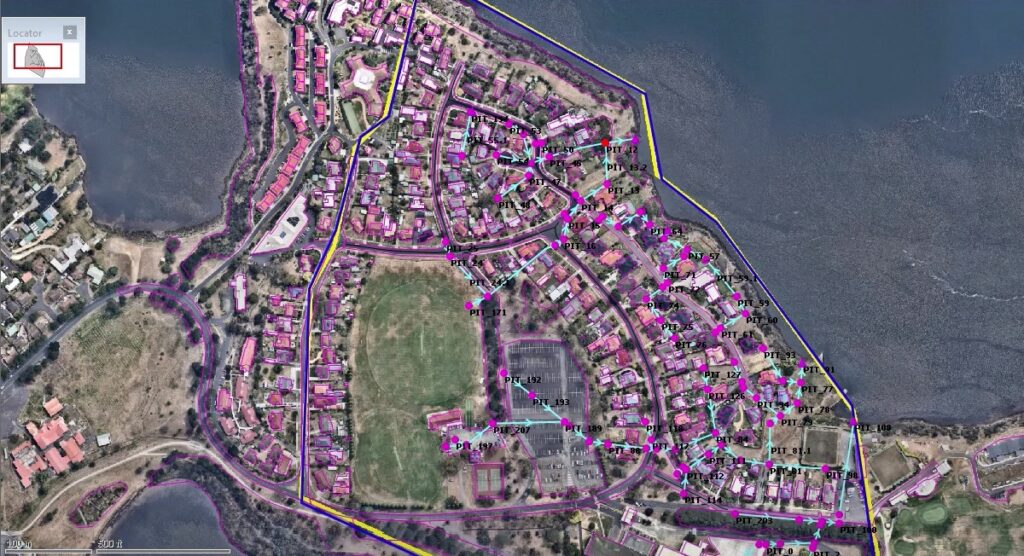
A look at a 1D storm sewer network model in InfoWorks ICM.
2D models, which are often used in conjunction with 1D models where appropriate, utilize a grid which spans a given floodplain. The grid establishes a connected series of spaces where 2D hydraulic calculations can be performed, which when strung together, create a much more accurate flood map over a given plane. In 2D models, the calculations are run to simulate flow forwards and backwards, just like 1D models allow for, but also left and right, giving indication of 2D flow direction. As you might imagine this means that the resultant model is far more accurate to reality. As a given grid, or mesh, gets finer and finer the accuracy to reality gets even closer as more and more equations are run on smaller and smaller areas.
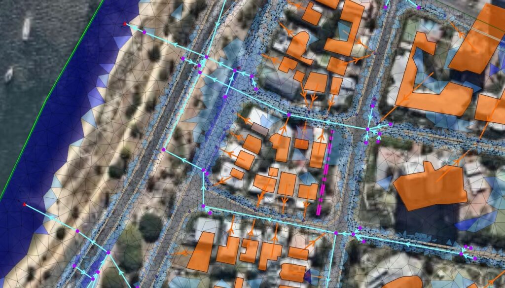
A 2D mesh for a given floodplain generated in InfoWorks ICM, combined with a 1D storm sewer model.
So, 2D models are essentially leveraging the same root math as 1D models, but to a much higher degree of frequency and accuracy across an entire floodplain, not just a series of subsequent cross-sections. With this description out of the way, there are still use cases for each, and pros and cons for why hydraulic modelers might need to use one or other.
In fact, many modelers use combined 1D and 2D models, where river channels or sewer systems are modeled in 1D, and banks and floodplains are modeled in 2D. As a result, the 2D flow data over a large area can inform the inflow data for the 1D model, leveraging the power of 2D calculations alongside the simpleness of 1D models for channels.
To 1D or to 2D… that is the question
The most significant reason a modeler might shy away from 2D models is simply due to the computational power needed to run them. There’s a general rule that hydraulic modelers use when scoping a given project and how to set up the model. If the length of a given floodplain is larger than 3 times the width, then 1D modeling will likely be accurate enough. What this looks like in reality: If a modeler needed to simulate a river that stretches 1,000 meters, or 3,280 feet, and the floodplain was only 100 meters, or 328 feet, wide, then the length would be 10X the width, providing a ratio of 10:1, which is greater than 3:1, meaning 1D modeling might be suitable in this situation.
When you take a moment to step back and think about it, this rule of thumb makes logical sense based on how the models work. 1D models are at their core a complex version of long addition from one cross section to the next. If your entire floodplain can be captured in a linear series of cross-sections, then 1D models will do just fine. When floodplains approach lower ratios of length to width, then each given cross-section in that 1D model would be so vast that the level of accuracy from the resultant calculations decreases widely. Thus, 2D models will be more accurate in this situation.
But there are other factors that go into choosing model type aside from this general rule of thumb.
Model factors where 1D might be more suitable
- Uni-directional flow: Flow is not expected to spread out across a plain significantly
- Well-defined channels: water clearly flows through defined channels or pipes in a uni-directional pattern
- Well-defined floodplains: flow in and out of given plains is well defined and known
- Limited elevation data: Scenarios where a given floodplain does not have enough known data to provide for an accurate 2D mesh
Model factors where 2D models are better
- Flow expected to spread: Surfaces where flow is not uni-directional and variance is expected
- Urban or complex areas: Models with complex topographical features necessitate 2D for model accuracy
- Specific hydraulic studies: Studies on wetlands, estuaries, and other hydrologic conditions
- High accuracy: Situations where model accuracy is needed above all else
1D models present a number of benefits, like being fast to run, good at representing channel flows and point feature infrastructure like bridges or weirs. For many more rudimentary hydraulic models and hydraulic modelers, 1D models are the good enough solution for the tools on hand. On the flipside, 1D models require a significant number of assumptions, like identifying major flow routes and complex set up of the system. They also deliver results that are poor in urban and complex areas, as well as don’t provide velocity distribution on a given floodplain.
2D models are far superior in that they are easy to set up, can be highly accurate, provide velocity and direction variation, and provide dynamic flood maps for a given floodplain. Today, 2D models are largely held back by a user’s computational power, often making 2D models slow to run. They also can struggle with point features, which is why combined 1D and 2D models are common. Lastly, for areas with very fine and variable topography and thus have high water flow, like rivers or channels, a very fine mesh is needed, compounding the computational power demand problem. These computational demand challenges are often solved by access to cloud computing for users, something available to InfoWorks ICM subscribers at no charge, making 2D models often the tool of choice for those with access to leading tools. With cloud access, models that might take hours or days to run locally can be finalized in minutes, leveraging the computing power of thousands of distributed machines.
1D and 2D modeling inside of InfoWorks ICM
Autodesk InfoWorks ICM is the leading integrated catchment modeling solution for engineers and modelers looking to run 1D and 2D hydraulic models. Inside of InfoWorks ICM Ultimate, users are able to build and run these models in a collaborative cloud-connected environment. Subscribers have access to unlimited cloud runs for their models, as we mentioned earlier, making the barrier of computational power for 2D hydraulic simulation practically nothing.
Ryan Brown’s crash course in 2D modeling in InfoWorks ICM