
Preserving Paradise: How Honolulu Is Combating Climate Change
By Roger Babcock Jr., Cari Ishida, Sarah Deslauriers, and Rachel Duncan

The last state to join the U.S. is leading in resiliency planning, serving as a model for others as storms and floods worsen.
Hawaii is an island state and, therefore, arguably one of the most vulnerable states to the direct and indirect impacts of climate change. The City and County of Honolulu are taking proactive measures to reduce the detrimental effects of climate change in the state.
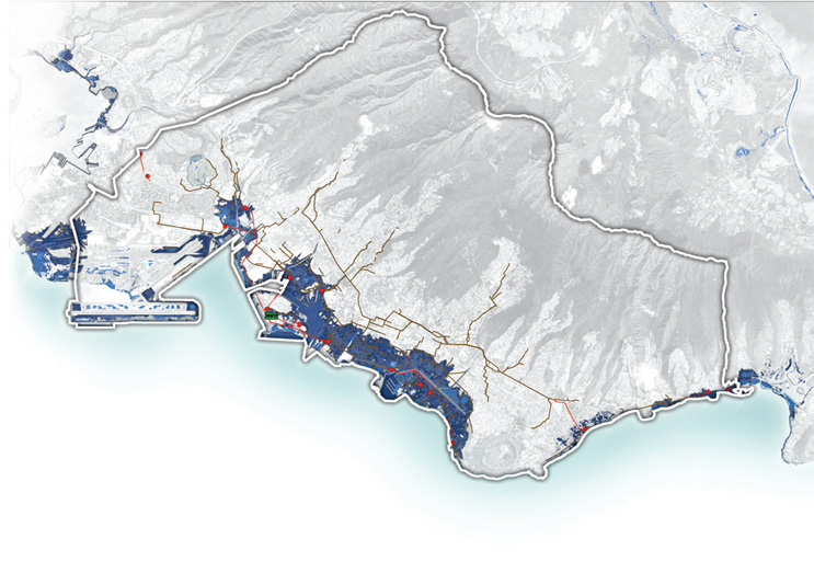
Together with the City and County of Honolulu’s Department of Environmental Services, Carollo completed the Climate Change Vulnerability Assessment and Resilience Plan for the Sand Island Sewer Basin (SISB) in January 2021. Carollo performed a climate vulnerability assessment of the wastewater facilities in the SISB. The flooding threats enhanced by climate change (specifically, sea level rise) included coastal erosion, tsunamis, hurricane storm surge, and 100-year flood events.
The City owns and operates the largest wastewater system in the state of Hawaii. The system includes nine wastewater treatment plants (WWTPs) and approximately 70 wastewater pump stations (WWPSs) on the island of Oahu. The basin is served by the Sand Island WWTP and a collection system composed of 580 miles of gravity pipes and force mains, 17 City-owned WWPSs, and one Army-owned WWPS. The City and County of Honolulu provide services and businesses that support the most significant economic drivers for the entire state. Thus, protecting critical wastewater infrastructure within the City and County of Honolulu is essential to supporting a thriving economy.
Vulnerability Assessment — Key Tools And Findings
Key tools and findings resulting from the climate change vulnerability assessment included:
- Detailed maps and cross sections illustrating the extent and depth of enhanced flooding threats to wastewater facilities within the SISB, including 17 WWPSs and the Sand Island WWTP (Figure 1).
- Categorization of vulnerability and risk (low, medium, severe) to wastewater facilities (WWPSs and the Sand Island WWTP)
- Identification of near- and long-term adaptive strategies to mitigate evolving threats.
- Recommended approach for implementing climate adaptation strategies.
- Considerations to facilitate regional collaborative discussions among agencies to coordinate climate change mitigation efforts.
Assessment Details
The vulnerability assessment used a two-pronged approach — a desktop analysis and site visits/interviews. The desktop analysis took into account critical facility information from drawings and compared them to historical observations and projected threat scenarios. The work products of this analysis included drawings that indicate critical flood levels and pathways, as well as aerial maps (Figure 2).
The project team leveraged available data sources, including Federal Emergency Management Agency (FEMA) flood insurance rate maps (FIRMs) and Pacific Islands Ocean Observing System (PacIOOS) maps.
The site visits were conducted jointly with City staff and were performed to confirm asset details and operations through observation and staff interviews.
This team determined the vulnerable areas in the SISB and recommended adaptive management strategies that will increase resilience to flooding and evolving climate change threats. Examples of the adaptation strategies that were considered include:
- Install watertight doors.
- Elevate exterior equipment.
- Install temporary and permanent flood barriers.
- Install flood walls for buildings.
- Elevate access roads.
- Elevate site grade.
- Reinforce or seal manholes.
- Restore or expand coastlines.
- Relocate or abandon facilities.
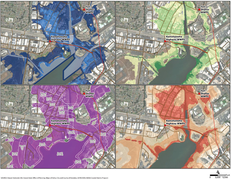
The maps and figures produced as a result of the assessment serve as visual tools to aid the City in clearly identifying and communicating the potential flooding risks due to climate change. These tools help the City demonstrate the need for facility hardening or other improvement projects to internal and external stakeholders. Visualizing the potential magnitude of the flood impacts sparks conversations and invokes a call to action to prepare for climate change.
Project Outcome
The City is currently starting a One Water plan that will leverage the tools, findings, and recommendations resulting from this climate change vulnerability assessment and resilience plan to further prepare for enhanced flooding impacts. In addition, the assessment approach can be replicated and applied to other City departments and their assets to prepare for flooding impacts related to climate change. In turn, use of the approach across City sectors would also position the City to hold collaborative planning sessions to develop holistic regional solutions that better leverage the City’s funds for its protection and increased resilience.
Acknowledgements
The authors of this article would like to acknowledge the City and County of Honolulu, Department of Environmental Services for their work in support of this project, including Jack Pobuk, Paul Christiansen, and Lisa Kimura. For more information on this project, please contact the City at ENV@honolulu.gov or 808-768-3486.
About The Authors
 Roger Babcock Jr., PhD, PE, is director of the Department of Environmental Services (ENV) for the City and County of Honolulu. ENV provides wastewater and solid waste services for the island of Oahu, including nine wastewater plants, 71 pump stations, 2,000 miles of collection system, refuse collection, transfer, waste-to-energy, and a landfill. Prior to joining the City in 2021, Babcock was a professor of civil engineering at the University of Hawaii for 25 years, where he conducted research on wastewater, stormwater, drinking water, and biosolids.
 Cari Ishida is the office manager for Carollo Engineers’ Honolulu, Hawaii, office and the project manager for the Sand Island Sewer Basin Wastewater Facilities Plan. She has over 20 years of experience on water projects, with an emphasis on long-range planning.
 Sarah Deslauriers, PE, ENV SP is a licensed professional engineer serving as Carollo Engineers’ Resilience and Sustainability Practice director. She has 21 years of experience, focused on climate vulnerability assessments, water, wastewater, biosolids, and energy resilience master planning, greenhouse gas emissions management, and regulatory/legislative advocacy.
 Rachel Duncan, PE, ENV SP is a senior engineer with Carollo Engineers based in San Francisco, CA. She specializes in climate change vulnerability assessments for water and wastewater systems and water supply planning projects with an emphasis on climate change impact modeling and analysis, alternatives analysis, and decision modeling. Rachel is the chair of AWWA’s Climate Change Committee.