
Another Summer Of Flooding Should Be A Wake-Up Call To Redesign Our Communities
By Joseph W. Kane

Hurricane Dorian has left a trail of devastation over the last few days, but an onslaught of destructive floods have hit communities all across the country this summer. From small towns in the Midwest and Southeast to large cities like Washington and New York, torrential rains have inundated homes, cut power, and disrupted lives. It’s no accident either. Climate change is fueling more floods, leading to mounting economic costs, and upending our ability to respond to growing risks.
Large storms like Dorian are hard to prepare for no matter what, but investing in more resilient infrastructure — including new green designs and technologies — is key to addressing long-term risks, even from daily rainfall. Rain gardens, vegetated buffers, and other improvements absorb stormwater, minimize floods, and reduce costs. But one project isn’t going to make a big difference. It’s only through a collection of systems working together that we have the power to create more resilient places for everyone, particularly in lower-lying, lower-income neighborhoods that bear greater flood impacts.
To manage our climate insecurity, communities need to redesign themselves into more environmentally and economically transformative places. That starts with clearly accounting for and addressing the gaps in our current urban designs.
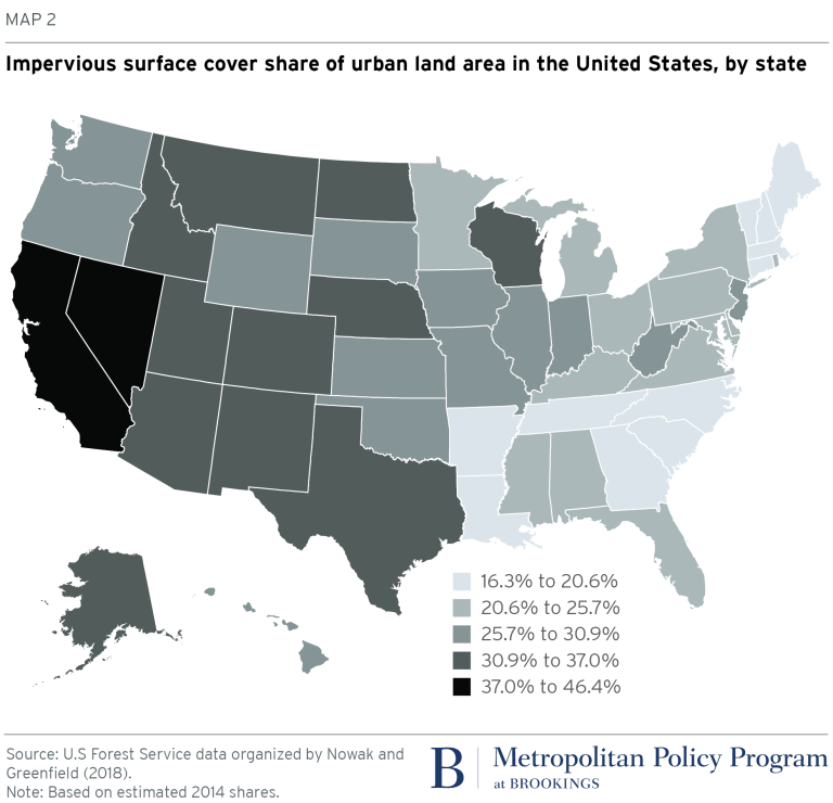
Decades of suburban sprawl and environmentally irresponsible development have provided expensive lessons in poor urban design, including overwhelmed rivers and sewers. But decades of urban science have also taught us that communities with more tree cover and less impervious surface cover (e.g. parking lots, roads, and other paved surfaces) are better positioned to handle floods and support more livable spaces. Data from the U.S. Forest Service make it possible to examine how these land and design characteristics vary across different states.
The urban tree canopy — the layer of trees and related natural features in an urban area — filters stormwater and provides many other benefits, including cleaner air. While trees cover about 39 percent of our urban land nationally, on par with long-standing environmental targets, their coverage varies from place to place. Eastern states tend to be more forested in general, but many urban areas that have endured significant flooding in recent years may lack widespread tree cover, including those in states such as Texas (26 percent), Iowa (27 percent), and Illinois (31 percent). Even more concerning is the fall in the urban tree canopy nationally, including an estimated loss of 138,000 acres each year from 2009 to 2014, or a 1 percent total decline over the five-year period.

As the country continues to urbanize, our development patterns have led to more impervious surface cover, making it harder for stormwater to naturally filter into the ground and better protect nearby homes and businesses. Impervious surfaces make up almost 27 percent of urban areas nationally, with high shares in western states such as California (43 percent) that have seen rapid sprawling development. Urban impervious surface cover is also on the rise, up nearly 132,000 acres each year from 2009 to 2014, or a 1 percent total increase over the five-year period.
Communities with declining tree cover and rising impervious surface cover are more susceptible to flood risk, and it’s crucial that private developers and public sector peers turn to more resilient designs. These efforts will need to reach all corners of the country; urban areas experiencing the biggest swings are found anywhere from Utah (+2.6 percent in impervious surface cover) to Indiana (+1.4 percent) to Delaware (+1.7 percent), as shown below. From 2009 to 2014, these ten states combined saw their urban tree canopy lose 14,000 acres each year and their urban impervious surface cover gain 29,000 acres each year.

Extreme and unpredictable weather makes it hard to prepare for all floods, and some communities will remain in harm’s way regardless of how many improvements they make. Meanwhile, others are simply struggling to stay ahead of their existing infrastructure maintenance needs, let alone taking on bigger and bolder investments. But that’s not an excuse for inaction. The more we delay, the more we all pay in the end. And while these redesigns aren’t going to happen overnight, communities can benefit from proactive thinking and investment in support of greater environmental and economic certainty.
There are several steps regional leaders can take to get the ball moving. We need to develop and implement more detailed measures to gauge land changes over time. While new data and mapping efforts are emerging, continued monitoring is needed to better estimate flood impacts, alter designs, and guide future plans. Likewise, experimenting with new funding and financing strategies — including new types of stormwater fees and procurement tools — can mobilize action around new projects and designs. But perhaps most important is the need for strong leadership to drive change, from individual planners and policymakers to regional utilities and economic development organizations. Los Angeles, for instance, recently named its first-ever city forest officer to promote urban canopy growth and expand community engagement. More places should follow their lead.
More floods are bound to hit in the coming months, and damage will likely follow. It’s time we break the cycle by redesigning and reinvesting in our communities.
Joseph Kane is a senior research associate and associate fellow at the Brookings Institution’s Metropolitan Policy Program.
This research was originally published by The Brookings Institution.