
Rethinking Master Planning In A Data-Rich Environment
By Jennifer Steffens, Eric Harold, Caroline Burger, and Tim Loper
Historically, utility master plans have provided project recommendations and expected short- and long-term capital costs to guide future infrastructure investments. While these plans remain foundational to long-term planning, the traditional approach often results in static reports that are revisited every five to ten years.
Today’s utilities operate in an increasingly data-rich environment shaped by expanding monitoring systems, advanced modeling capabilities, and growing volumes of infrastructure information. At the same time, they are operating in a far more dynamic environment shaped by rapid growth, climate variability, aging infrastructure, and increasing regulatory complexity. Digital planning tools are transforming the master planning process from a periodic study into a continuously updated decision-support system that integrates data, models, and operational insight.
A Game Changer
As utilities invest in sensors, SCADA systems, GIS platforms, asset management programs, and advanced modeling tools, the volume of available data has increased drastically. However, many organizations still struggle to translate that data into actionable planning decisions.
Digital planning tools bridge this gap by integrating modeling results, asset data, capital planning information, and development projections into unified platforms that allow utilities to continuously evaluate system performance and investment priorities.
Emerging tools to support utilities’ capital improvement plan (CIP) development and implementation needs include:
- Interactive dashboards that connect planning assumptions to operational performance and stakeholder reporting.
- Dynamic management of CIPs that allow ongoing tracking, CIP modification, and project reprioritization.
- GIS-based digital master plans that allow utilities to visualize and track development, understand water supply and demand, and access and visualize model results.
- Asset management tools that integrate condition assessments, forecasting, rehabilitation and replacement plans, and capital costs.
- Field data collection solutions that improve data quality and accelerate updates to planning models.
A capacity tracking tool can seamlessly monitor growth and development without accessing the sewer model and performing time-consuming simulations.
Meeting these needs requires the ability to adapt to changing conditions while integrating information from multiple data sources. By connecting planning models, infrastructure data, and capital investment strategies within a digital planning environment, utilities can evaluate evolving assumptions related to growth, financing, and development impacts over time. This approach transforms master planning from a static report into a dynamic decision-support framework that continues to inform infrastructure investments and operational decisions long after the initial planning process is complete.
Digital Success Stories
Here, we explore just a few examples of how Carollo Engineers has helped utilities navigate change through adaptive planning approaches. These solutions support better prioritization of infrastructure investments, renewal of aging facilities, and management of system growth and development.
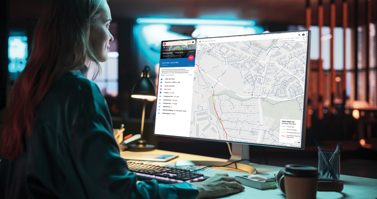
Capacity Tracking for Easy Access to Modeling Results
One of Carollo's clients was experiencing rapid growth along the expanded Washington DC regional transit corridor, placing increasing stress on existing infrastructure and impacting regional utility contractual agreements. To better manage these pressures, the planning effort incorporated growth projections, system complexity, and hydraulic modeling results into an accessible digital environment that allows staff to explore system capacity and development through an intuitive GIS interface.
By making model results and planning analyses readily available, utility staff can quickly evaluate development proposals, understand their implication for system capacity, and respond to developer inquiries without requiring specialized modeling expertise or time-consuming simulations. This approach enables project owners to track growth and infrastructure capacity more effectively while keeping planning information current as development continues.
StoryMaps to Empower Smart Decisions
A Texas neighborhood was struggling with chronic nuisance flooding along with more severe flooding impacts during larger storm events. The client's goal was to reduce the overall flood risk in the area through development of a comprehensive stormwater master plan that identifies and prioritizes short- and long-term flood mitigation solutions.
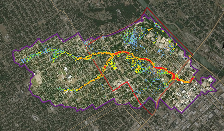
Online StoryMaps provide easy access to complex master plan details and use data visualization to illustrate results and recommendations in a compelling, user-friendly format.
![]()
Monitoring the budget and schedule of a CIP's top water and wastewater projects over time allows clients to allocate resources and make necessary adjustments to optimize their investment.
To improve accessibility and communication of the plan’s findings, the results were presented through ArcGIS StoryMap, an interactive, web-based platform that integrates maps, data visualizations, and narrative explanations. This approach allows stakeholders to explore flood risks, understand recommended projects, and view planning information in a clear and engaging format, making complex technical analyses easier to communicate and supporting more informed community and decision-maker discussions.
CIP Management at Your Fingertips
A Carollo client in British Columbia provides water and wastewater services to 13 municipalities and three electoral areas in the southern portion of Vancouver Island and the surrounding Gulf islands. Its service area includes 460,000 customers and the territories of several First Nations.
To support implementation of its CIP for treatment and conveyance infrastructure, the client sought a more dynamic way to track projects and evaluate changes over time. By integrating capital planning information with spatial data and program schedules, the resulting planning environment allows utility staff to visualize projects across the system, understand how adjustments to timing influence overall program delivery, and evaluate capital spending throughout the life of the CIP.
Looking To The Future
As utilities face increasing demands from population growth, aging infrastructure, climate variability, and evolving regulations, the ability to translate data into informed infrastructure decisions is becoming increasingly important. Digital planning environments are helping utilities move beyond static reports toward continuously updated planning frameworks that connect models, infrastructure data, and capital planning strategies.
By integrating information from systems such as GIS, asset management platforms, hydraulic models, and financial planning tools, utilities can develop a more complete understanding of how infrastructure performs today and how it may need to evolve in the future. These connected data environments allow planning assumptions, growth projections, and investment priorities to be updated as conditions change.
Looking ahead, advances in analytics and machine learning will further enhance the ability of utilities to anticipate system needs, evaluate investment scenarios, and identify emerging risks earlier. Rather than replacing engineering judgment, these capabilities will augment it — providing engineers and utility leaders with deeper insight into system performance and infrastructure needs.
Jennifer Steffens, PE, is a vice president and director of digital water at Carollo. With 21 years of experience, Jennifer focuses on helping utilities use digital technologies to improve infrastructure decision making, operational performance, and long-term resilience.
Eric Harold, PE, BCEE, is a vice president with Carollo. He is a nationally recognized authority on strategic collection system planning and dynamic sewer modeling and has participated in more than 110 regional collection system master plans and studies throughout the US.
Caroline Burger, PE, is a vice president and chief stormwater technologist at Carollo. She has 26 years of experience in urban hydrology, stormwater management, and water quality solutions.
A vice president with Carollo, Tim Loper, PE, is the firm’s infrastructure master planning services lead and has served on more than 100 water, wastewater, stormwater, and/or recycled water master plans and modeling projects in the last 25 years.