
NWS Launches New Website To House The Next Generation Of Water Forecast Services And Flood Inundation Maps
Access to water data and water prediction services from NOAA’s National Weather Service just got easier.
The agency has unveiled a new experimental website, called the National Water Prediction Service, as the gateway to the agency’s water data and forecast information.
The new site is mobile-friendly, modern, and efficient, while the infrastructure is intuitive and flexible – allowing users to make sound decisions when it comes to water. It also centralizes data from the Advanced Hydrologic Prediction Service and the Office of Water Prediction.
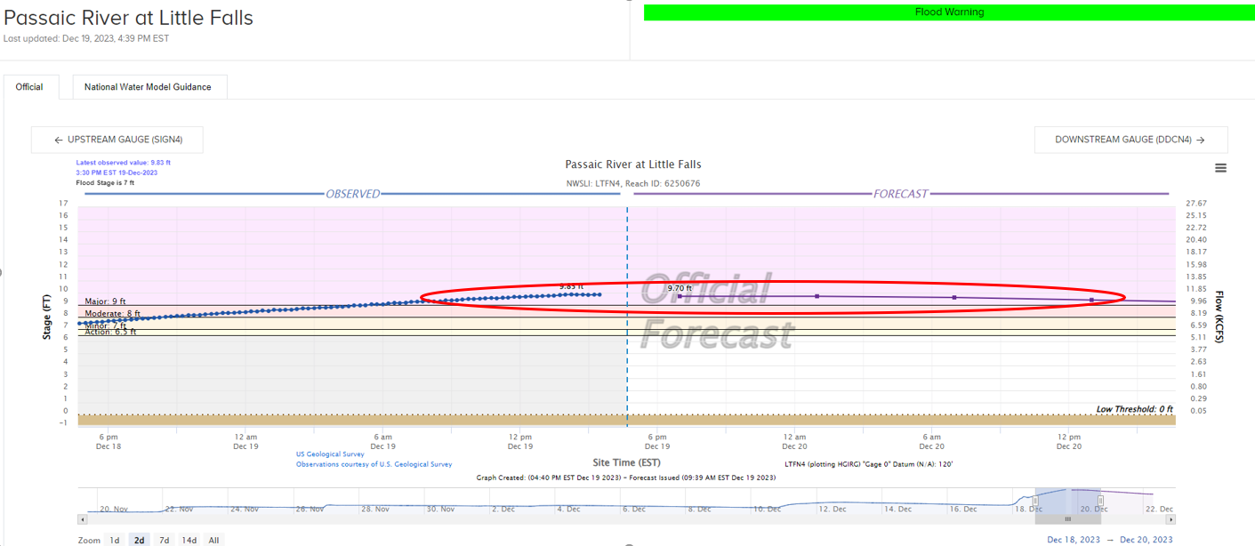
One of the more popular products on the Advanced Hydrologic Prediction Service is getting a face-lift on the National Water Prediction Service - hydrographs. Hydrographs (seen above) visually show water level observations and forecasts in a single graphic. When a gauge along a river experiences heavy rainfall and is forecast to rise above the flood stage, National Weather Service hydrologists and personnel can relay this information to emergency managers and the public. These new hydrographs show observations over the past 30 days, compared to only 72 hours on the old website. River flood forecasts will continue to look ahead several days in advance, up to 7 days.
This entire range of observations and the upcoming forecast are adjustable to a timeframe suitable for people who need this data, like emergency managers. The hydrographs include other helpful information, such as gauge location, historical crests, photos and FEMA National Flood Hazard Layers.
The National Water Prediction Service also features:
- An expansive layering and map option with capability of viewing current watches, warnings, and advisories.
- The National Water Model, which offers guidance for the first time to ungauged areas of streams and creeks across the country.
- Groundbreaking Flood Inundation Mapping services that currently cover 10 percent of the U.S.
- For more information Flood Inundation Mapping please refer to our news release from last September.
- Mobile capability with downloadable GIS data available.
The National Water Model is a hydrologic modeling framework that simulates observed and forecast streamflow over the continental United States. The model forecasts complement official National Weather Service river forecasts for 4,000 locations with approximately 3.4 million additional river reaches or areas that do not have river gauges.
So, what does this mean for you?
Let’s say you live along a stream in Nebraska or a creek in Pennsylvania and a heavy rainfall event is forecast for your area. The National Water Model will let you know if water from these streams and creeks may top their banks and flood in your immediate area.
The National Weather Service is always looking for ways to improve the support services we provide to communities nationwide. Whether someone needs the latest river flows for boating, determining how much water is available for dam operations, or taking protective action ahead of an upcoming major flood, this new water website will provide everyone with the information they need to make the best possible decisions.

Resources:
Source: National Oceanic and Atmospheric Administration (NOAA)