
NOAA And Partners Find Smaller-Than-Anticipated Hypoxic Zone In Gulf of America
Tropical Storm Bertha mixed water column, reducing size
NOAA-supported scientists announced today that this year’s Gulf of America hypoxic zone is approximately 1,332 square miles, making it the 2nd smallest zone on record in 40 years of measurement. Hypoxic areas, also called “dead zones,” are areas with little to no oxygen in the water, which can negatively impact fish, shellfish, corals and aquatic plants by making critical habitat unavailable to bottom species.
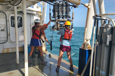
The annual hypoxic zone survey was led by scientists at Louisiana State University and the Louisiana Universities Marine Consortium (LUMCON). The survey cruise was conducted aboard the LUMCON research vessel Pelican from July 24-30. Data from the survey is available online for the public.
The measured hypoxic zone is smaller than anticipated this year due to Tropical Storm Bertha passing through the northern Gulf of America on the eve of the cruise. Tropical storm-force winds and high waves churned the water across the cruise area and mixed oxygen-rich surface waters down to the seabed. Although the cruise did not capture the full extent of the zone, years with abnormal weather events help researchers better understand how these events impact the breakup and reformation of hypoxia in the Gulf and ultimately lead to better models and forecasts.
"Measuring the hypoxic zone provides more than just a score card of the Gulf's ocean oxygen levels — it helps us better understand the interconnectivity of our nation’s land, waterways and ocean,” said Timothy Petty, Ph.D., NOAA assistant secretary of commerce for oceans and atmosphere and deputy administrator. “The data we've gathered from 40 years of measurements in the region will help inform the development of better management strategies upstream as part of our ongoing efforts to mitigate future impacts in the Gulf.”
The information helps scientists and coastal managers understand how low-oxygen events impact the overall growth, reproduction, and habitat usage of key fisheries and help develop mitigation measures to alleviate potential damage to affected commercial and recreational fishing industries and tourism.
How hypoxic zones form
Excess nutrients that reach the Gulf of America via the Mississippi-Atchafalaya River Basin stimulate an overgrowth of algae. When these algae die and decompose, they deplete oxygen in the water as they sink to the bottom. The resulting low oxygen levels (hypoxia) cause animals, like fish and shrimp, to leave the area.
In June, NOAA predicted an above-average-sized Gulf of America hypoxic zone of 7,027 square miles, based primarily on Mississippi River discharge and nutrient runoff data from the U.S. Geological Survey. The measured size fell outside the uncertainty range for NOAA’s ensemble forecast. The forecast models assume typical weather conditions and only have a limited capacity to factor in major storms such as Tropical Storm Bertha, which can disrupt the hypoxia zone around the time of the cruise, as was the case this year.
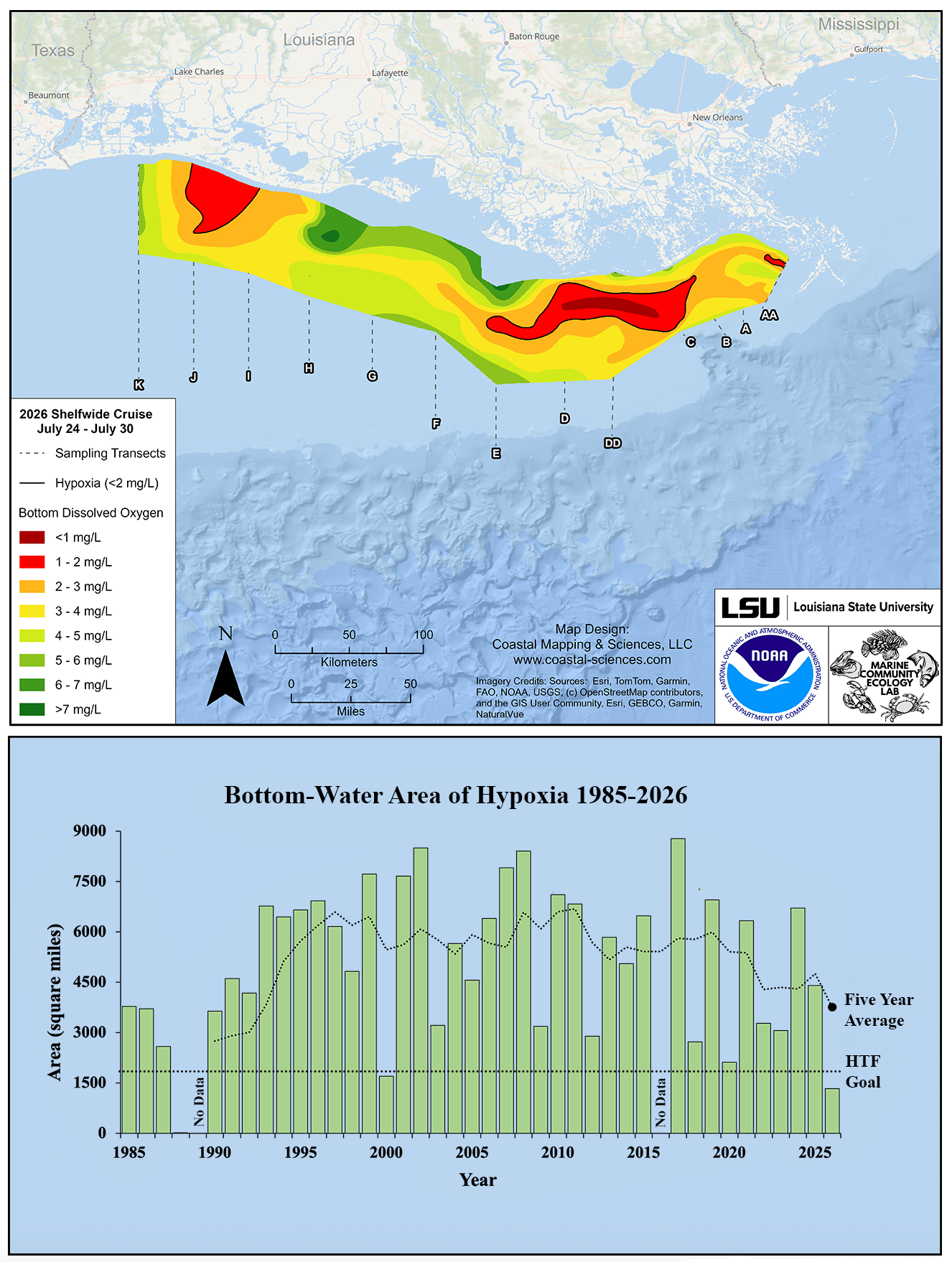
Image showing (Top) Map of measured Gulf hypoxia zone, July 24 - 30, 2026. Red area denotes 2 mg/L of oxygen or lower, the level which is considered hypoxic, at the bottom of the seafloor. (Bottom) Long-term measured size of the hypoxic zone (green bars) measured during the ship surveys since 1985, including the target goal established by the Mississippi River/Gulf of America Hypoxia Task Force and the 5-year average measured size (black dashed lines). Image credit: NOAA/LSU
Hypoxia Task Force efforts
The annual hypoxic zone measurement informs the collective efforts of the Mississippi River/Gulf of America Hypoxia Task Force (HTF) which was established to accelerate nutrient strategies by working collaboratively with member states, agriculture partners, the wastewater sector and industry to reduce excess nitrogen and phosphorous in surface waters. This state and federal partnership uses the measurement to track progress toward its long-term goal of reducing the five-year average extent of the hypoxic zone to fewer than 1,900 square miles by 2035.
In June, EPA, as co-chair of the HTF, reported on progress reducing excess nutrients, including the key finding that state-led actions helped reduce nitrogen enough to meet the target set for 2025. Reducing excess nutrients in the Mississippi/Atchafalaya River Basin not only reduces the size of the Gulf of America hypoxic zone, it also improves water quality in rivers and streams across middle America to strengthen water resources.
While each NOAA-supported research survey provides a one-time snapshot of the hypoxic zone, the five-year average accounts for year-to-year variability in conditions affecting the zone. The five-year average size of the Gulf of America hypoxic zone is now 3,745 square miles, almost two times the 2035 goal.
“The Gulf of America is a national treasure and a critical economic engine for coastal states that EPA is proud to support as a co-chair for the Hypoxia Task Force,” said Jessica Kramer, Environmental Protection Agency (EPA) assistant administrator for water. “EPA supports the leadership of HTF states that are implementing their tailored nutrient reduction strategies to accelerate progress that benefits local communities upstream and the Gulf economy downstream.”
Climate, weather, and water affect all life on our ocean planet. NOAA’s mission is to understand and predict our changing environment, from the deep sea to outer space, and to manage and conserve America’s coastal and marine resources. See how NOAA science, services, and stewardship benefit your community: Visit noaa.gov for our latest news and features, and join us on social media.
Source: NOAA