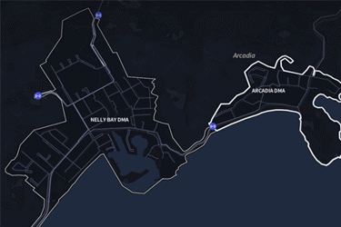
Map view
Effortlessly explore your water network with Qatium’s default map view, much like familiar map-based applications. Navigate around the map to see your network from different perspectives.

A clear, actionable network view for confident decision-making.
Visualize your water network in a modern, digital environment that is engaging & intuitive to use. View flow or pressure with dynamic animations that support quick water network analysis.
Get a control room -like overview with Synoptic view, or use Satellite view to understand the context of operational decisions. Understand how assets are behaving so decisions are made confidently before applying them in the real world.
Unlike other digital water management tools, Qatium’s user interface (UI) is designed to delight, while giving network operators a toolkit for comprehensive water network analysis.
Map view
Effortlessly explore your water network with Qatium’s default map view, much like familiar map-based applications. Navigate around the map to see your network from different perspectives.
Satellite view
Gain invaluable context for network operations with Satellite view. Visualize the surrounding terrain of your network: elevated areas, man-made structures, or forests, etc.
Synoptic view
Get a high-level representation of your water network with Synoptic view. Reduce the noise of larger networks with a control room -like view of major assets, their performance, and interconnections for more focussed water network analysis.
Pressure
See a granular view of system pressure. Find the minimum customer pressure points to ensure you’re compliant and the maximum pressure locations to check for vulnerabilities like areas of higher leakage or potential bursts.
Flows
Visualize flow in your water network at a glance. Use dynamic animations to the direction and amount of water flowing for fast water network analysis.