Mapping 'Flash Flood Alley'

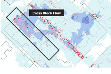
In the flood-prone city of San Marcos, Texas, located in the infamous "Flash Flood Alley," Lockwood, Andrews, and Newman Inc. (LAN) faced a challenging task: protecting the growing population from recurring floods. Leveraging cutting-edge InfoWorks ICM software, LAN built a highly detailed 1D and 2D hydraulic model of the Purgatory Creek Watershed, identifying that undersized storm drains were causing overland flooding. This digital twin of the stormwater network allowed them to map out critical flood risk zones, pinpointing over 100 homes at high risk during significant storm events.
The insights from this model provided the city with the ability to make precise, data-driven decisions for flood mitigation and future urban development. By creating an evergreen digital resource, LAN ensured that San Marcos could continuously update and refine its flood prevention strategies as the city grows. This case study highlights how modern engineering and technology can transform how municipalities tackle environmental challenges, helping protect communities from the escalating threat of extreme weather.
Get unlimited access to:
Enter your credentials below to log in. Not yet a member of Water Online? Subscribe today.
