
Coastal Wetlands Can't Keep Pace With Sea-Level Rise, And Infrastructure Is Leaving Them Nowhere To Go

By Randall W. Parkinson, Florida International University
Wetlands have flourished along the world’s coastlines for thousands of years, playing valuable roles in the lives of people and wildlife. They protect the land from storm surge, stop seawater from contaminating drinking water supplies, and create habitat for birds, fish, and threatened species.
Much of that may be gone in a matter of decades.
As the planet warms, sea level rises at an ever-faster rate. Wetlands have generally kept pace by building upward and creeping inland a few meters per year. But raised roadbeds, cities, farms, and increasing land elevation can leave wetlands with nowhere to go. Sea-level rise projections for mid-century suggest the waterline will be shifting 15 to 100 times faster than wetland migration has been clocked.
I have been studying coastal geology and wetlands for more than 40 years. The rates of sea-level rise that we’re seeing now mean portions of today’s coastal wetland ecosystems will be lost to the ocean in the years and decades to come at a tempo never seen before.
Wetland Plants Were Able To Keep Pace In The Past
The presence of expansive wetlands along the coasts is in large part because sea level has been relatively stable for millennia.
Wetland plants could easily adapt to small changes in the ocean level because those changes were typically less than 1 millimeter per year. The plants naturally create or trap sediment, building elevation to keep up with rising seas. Wetland ecosystems are also adept at migrating horizontally and therefore could colonize areas of the coastline that were slowly flooded over time.
However, the world’s climate began to change about a century and a half ago. Fossil fuel combustion in factories and vehicles sent increasing amounts of carbon dioxide into the atmosphere, raising global temperatures. This also warmed the oceans, causing them to expand, and accelerated the melting of glaciers and ice sheets. The combination of thermal expansion of seawater and melting land ice has added volume to the ocean, causing sea level to rise at ever-faster rates.
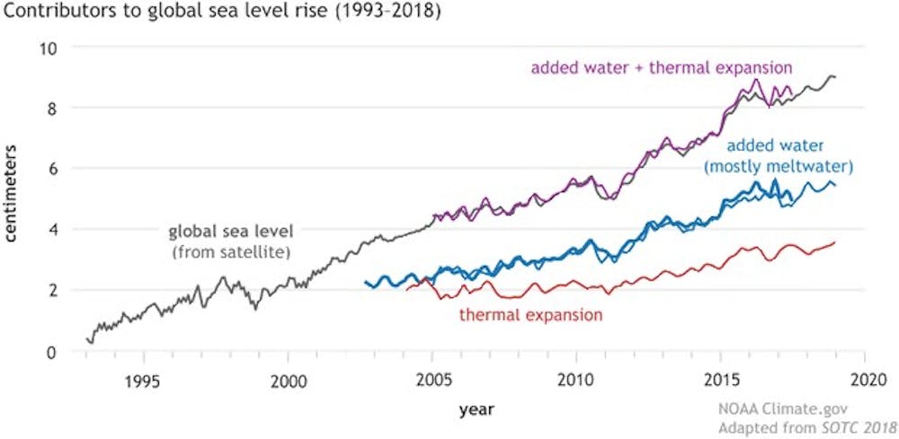
Water level data collected by the National Oceanic and Atmospheric Administration at gauges distributed along the U.S. coast indicates the average rate of sea-level rise is now about 10 millimeters per year — much faster than in the past — and it is expected to continue accelerating. During the second half of the 21st century, scientists expect sea-level rise to average about 30 millimeters per year. That’s 30 times faster than it was rising before the Industrial Revolution.
Sea Level Is Rising Faster Than Wetlands Can Adapt
The rates of sea-level rise along the mid-Atlantic and southeastern U.S. coasts are now faster than most coastal wetland plant communities can build elevation.
Within decades, it is very likely that much of these crucial ecosystems will drown. Areas once occupied by a lush, expansive, and contiguous coastal wetland ecosystem will, over time, become riddled with small, isolated ponds that enlarge, interconnect, and eventually transform to open seawater.
A regional analysis I recently conducted of published horizontal rates of wetland migration along the U.S. mid-Atlantic and eastern Gulf of Mexico coastal plains suggests wetlands can move inland at an annual pace measured in meters to tens of meters. In the same areas, however, theoretical rates at which the shoreline will move inland — calculated using NOAA sea-level projections in the year 2050 — range between 100 to 150 meters per year. That’s 15 to 100 times faster than wetlands can move.
The inundation models that scientists typically use to emulate coastal wetland resilience to rising seas assume wetlands will migrate inland at the same rate as the shoreline. As a result of the work I recently completed, it appears the models have overestimated coastal wetland resilience and that wetland losses this century will be higher than predicted.
Even under the most ambitious scenarios for reducing carbon dioxide emissions, sea-level rise will likely continue to accelerate this century. That means the loss of wetland ecosystems as they currently exist along our coastlines will continue for generations as the climate continues to warm and the oceans rise.
3 Ways To Protect These Valuable Ecosystems
So, what can be done to save our coastal wetlands? What actions can be undertaken to minimize the loss of these ecologically and economically important areas?
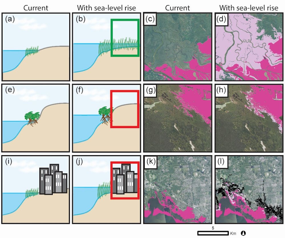
First, land managers could implement programs to acquire or create conservation corridors adjacent to areas where coastal wetlands currently exist. These undeveloped or natural landscapes will provide a pathway through which the wetlands can move inland as sea level rises.
Second, it seems ever more urgent to remove human-built structures — roads, dikes, levees — that will prevent the landward advance of coastal wetlands.
A project in Oregon did this by removing an earthen dike to allow the wetlands to migrate. In South Florida, engineers elevated miles of U.S. Highway 41, locally known as the Tamiami Trail, between Miami and Naples to allow the resumption of water flows that had been cut off.
Finally, in areas historically drained for agriculture and flood control, surface water management projects can restore freshwater flow toward the coastal zone. In South Florida, for example, rainwater in the Everglades prevented salt water from advancing underground — until extensive canals were built to drain the region for development and agriculture. Several large water management projects are now redirecting rainwater back into the Everglades to slow the advancing underground saltwater plume, which can be lethal to freshwater wetland and upland plant communities.![]()
Randall W. Parkinson, Research Associate Professor in Coastal Geology, Florida International University
This article is republished from The Conversation under a Creative Commons license. Read the original article.