
Applying Two Flood Models To Cross-Check And Improve Each Other — And Maybe Saving A Downstream Village In The Process
By Rex Gamble, EIT and Mia Hildebrandt, CFM, PE, ENV SP

Getting a second opinion is a time-tested piece of wisdom. During a recent project for a municipal water supply utility, we found that this advice also applies to modeling the effects storms have on the municipality’s reservoirs and dams, and the potential flooding impacts downstream of the dams.
We had the opportunity to put this good advice to the test as we applied two leading hydrologic and hydraulic computer modeling systems to identify the potential impacts to a U.S. water supplier client’s large, complex, multi-dam water supply system that covers an area roughly the size of the entire city of Washington, D.C.
The models we used, developed by the U.S. Army Corps of Engineers Hydrologic Engineering Center (HEC), were HEC-HMS, or Hydrologic Modeling System, and HEC-RAS, or River Analysis System. HEC-HMS focuses on hydrology, or how rainfall is transformed into runoff within a watershed. It simulates stream flows (hydrographs) at various points in the watershed, factoring in rainfall amounts, watershed shape, soil type, land use, and development, including the extent of impervious or paved surfaces. It is a widely used tool used to estimate how much and how fast water enters a given river system during a storm.
HEC-RAS is widely used for hydraulics, which is how water moves overland, through channels and floodplains, and how rivers respond to varying amounts of water. The user inputs river flow and the model simulates how water travels, spreads, and whether it overtops riverbanks or, more importantly in our case, dams. HEC-RAS enables us to map flood extents, visualize water surface elevations and velocities along river networks, and evaluate potential dam break scenarios and subsequent risks to property and life downstream of the dam.
Our project involved:
- Projecting whether a given dam’s spillway can safely pass the flood resulting from the Probable Maximum Precipitation (PMP), which is an estimate of the greatest rainfall that could fall in a specific area and timeframe.
- Evaluating flow hydraulics in spillway discharge channels that have erosion issues.
- Evaluating how gate operations can affect reservoir levels during floods, including mitigating flood risks.
- Developing maps of the areas that would be inundated in the event of a dam breach during normal (sunny day) conditions and during flood conditions.
Due to the nature of our complex water system where each dam of interest fed into the next dam of interest, we encountered a unique situation where the hydrologic modeling in HEC-HMS and the hydraulic modeling in HEC-RAS overlapped. We used this unique opportunity to have HEC-HMS and HEC-RAS cross-check each other to develop more robust, reliable models and mapping for our water supplier client. One key difference we observed between the two model results was the estimated reservoir water surface elevations during floods events. Naturally, we investigated this difference further.
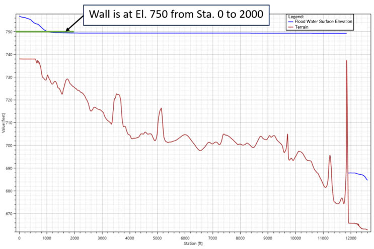
Non-Level Reservoir Water Surface Elevation Profile
The image shows a water surface elevation profile through one of the dam reservoirs from HEC-RAS. Between stations 0 and 2000 there is a wall at elevation 750 feet (in green) which is a flow pathway not located directly at the dam and that activates only during extreme flooding. The profile (from HEC-RAS) shows a relatively flat water surface below the elevation of the wall from the dam to the wall between stations 11,800 to about 1000, but then shows a non-level water surface above the elevation of the wall between stations 0 and 1000. The HEC-HMS model only “sees” the same flat water elevation throughout the entire reservoir, which would indicate that the wall would not activate, but HEC-RAS “sees” the higher elevations through non-level pool routing, which indicates that the wall is activating and passing water downstream.
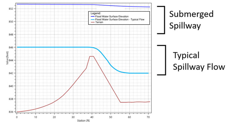
Spillway Submergence Water Surface Elevation Profile
The image shows a conceptual spillway weir with a typical spillway flow and a submerged spillway flow in which the weir becomes submerged by high water in the spillway channel. When the submerged spillway flow occurs, it reduces the efficiency of the weir to pass water. The HEC-HMS model cannot “see” when this submergence occurs and assumes a typical spillway flow profile is present without inefficiencies. The HEC-RAS model does “see” when this spillway submergence occurs and accounts for the resulting inefficiency of the weir, which is crucial for accurately assessing the capacity of the spillway.
The HEC-RAS model, with its more rigorous calculations, was able to pick up on issues not “seen” in HEC-HMS model due to its simplified modeling methodologies. These seemingly small but impactful disparities between the two models included the reduction in efficiency of certain spillways during floods due to them becoming submerged by high water in the spillway channel. In addition, the HEC-RAS model results showed lower travel times and flood wave velocities between dams than the HEC-HMS model results, which was largely due to the wide floodplains despite the steep channel slope. The most crucial difference observed between the two models was the existence of flow pathways not located directly at the dam and that only activated during extreme flooding, which created inundation risks for a downstream village that had not been identified in previous studies. For local emergency management officials, this is tremendously valuable information for public safety.
As we discovered these disparities between the two models, they were rectified by applying output data from the HEC-RAS model as inputs into the HEC-HMS model. This became an iterative process because revising the HEC-HMS inputs changed the flooding results which required updates of the HEC-RAS model. Every time we made a change in one model, we had to make sure that change was reflected in the other, and vice versa, since both the HEC-HMS and HEC-RAS models represented the full dam system, hence how we were able to use both models to cross-check each other.
One of the biggest challenges we faced was ensuring that our iterative modeling updates resulted in converging results between the two models all while keeping track of various tweaks to the input and output data. Ultimately, we needed to make sure that the flood discharge and volume, and reservoir elevations at each dam generated from HEC-HMS reasonably aligned with the flow characteristics estimated by HEC-RAS for the same flood event. Minor differences were to be expected, given the greater discretization of data and hydraulic complexity in HEC-RAS versus the more parameters-based HEC-HMS approach. A key lesson learned during this process was that when significant differences between the modeling outputs are observed, it is typically a good time to check data inputs.
In evaluating this water supply system, we provided our client with robust and refined hydrologic and hydraulic models which were used to assess the water supply dams’ hazard potentials and potential flood risk to communities downstream of the system. Although time was spent troubleshooting and resolving some complex conundrums in HEC-HMS and HEC-RAS, we were able to identify a downstream village in the inundation zone of the water supply system which was not previously included in inundation maps. By getting a second opinion (i.e., cross-checking the two models) we effectively helped this downstream village become safer by raising awareness about the potential flood hazard risks.

 Rex Gamble and Mia Hildebrandt are both Project Managers/Water Resource Engineers for GZA GeoEnvironmental Inc., an employee-owned, multi-disciplinary firm providing environmental, ecological, water, geotechnical, and construction management services from 35 U.S. office locations.