
Source Water Protection: There's An App For That
By Danielle Dumont, Marketing Manager, The Freshwater Trust
In Oregon, a mobile toolkit helps promote healthy ecosystems and protect community drinking water.
To continue supplying high-quality drinking water to ratepayers, many municipal utilities are looking outside the box. Miles beyond the walls of their drinking water facilities, they are focusing on protecting the water supply at its source and discovering that new technology can play an increasingly important role in restoring the forests and streams within their service areas.
For example, the Eugene Water & Electric Board (EWEB) in Eugene, OR has spent the last four years working with a number of partners and landowners on a program to protect healthy riparian — or streamside — forests around its sole source of drinking water for more than 200,000 residents. EWEB’s Voluntary Incentives Program (VIP) focuses on protecting approximately 9,500 acres of riparian forestlands along the McKenzie River and its tributaries.
Under the VIP, landowners with property in the area that meets specific standards for ecologically-functional riparian areas can qualify to receive annual payments and other incentives in return for long-term protection agreements. Landowners who do not meet these standards for compensation can still enter the VIP to restore degraded riparian areas and may be eligible for protection incentives once standards are met.
Into The Woods
Healthy riparian forests, consisting of a mix of rushes, grasses, shrubs, and trees, provide a suite of benefits for downstream water users. These benefits include flood mitigation, erosion control, pollutant filtration, and water-cooling shade, in addition to providing habitat for salmon and other regulated species in western states.
In 2014, EWEB and its partners began a pilot project to test the VIP concept with 15 landowners. The results of the pilot are informing the feasibility of a full program implementation in 2016. Part of the pilot includes the development of riparian vegetation survey protocols and standards, as well as testing The Freshwater Trust’s StreamBank® Monitoring app, a digital data collection tool for surveys. The Freshwater Trust is a nonprofit organization that protects and restores freshwater ecosystems using science, technology, and incentive-based solutions.
“StreamBank Monitoring is being used to assess and quantify the level of function in riparian forests affecting EWEB’s source water,” said Olivia Duren, riparian analyst for The Freshwater Trust. “With the data from StreamBank, EWEB can make recommendations to landowners for protecting high-quality woodlands and floodplains or restoring degraded areas.”
StreamBank Monitoring is part of the larger StreamBank patented toolkit of web-based and mobile applications for watershed restoration planning, monitoring, and tracking. StreamBank allows municipalities, utilities, and conservation partners engaged in source water protection to better understand the economic and environmental returns of restoration projects.
“StreamBank has evolved since 2007, when we first developed a version of it to help streamline grant funding and permitting for watershed restoration projects,” said Alan Horton, managing director of The Freshwater Trust. “Since then, we’ve continued to expand and adapt the platform to meet the needs of various projects and partners, including time-saving tools for characterizing streamside vegetation function for source water protection programs.”
StreamBank Monitoring is a popular tool in the StreamBank toolkit. It is a tablet-optimized app for collecting project data in the field and compiling that data for analysis and reporting. There are nine features in the app, including vegetation monitoring, riparian function assessments, shade measurements, photo point monitoring, redds surveys, and substrate monitoring.
“The StreamBank Monitoring app is built on a monitoring protocol that is flexible enough to be used for various projects but also specific enough to be especially useful for vegetation monitoring,” said Sharon Gordon, ecosystem services analyst for The Freshwater Trust. “This places the app squarely in between simple, out-of-the-box monitoring apps and custom-made apps that aren’t easily transferrable to other types of data collection.”
A Look In The Toolbox
The StreamBank Monitoring app is geared toward riparian vegetation actions. It features a user interface designed to mimic workflow in the field and provide a visual record of tasks completed to help organize efforts on-site and avoid data collection omissions.
The built-in validation rules help ensure that data collection is complete and that values are within an expected range. It’s possible to carry forward relevant data from previous sampling events (e.g., location latitude and longitude) to maximize efficiency. The menu selections significantly speed up data collection versus written notes, which also improves data quality by helping ensure that all users are documenting site conditions in the same way and directing attention to all major factors, such as browsing by wildlife, that could damage plantings. A quantitative vegetation monitoring feature is compatible with a wide variety of protocols and common metrics; for example, the app is flexible enough to allow the user to measure the amount of woody understory cover in terms of stem density, cover, or both. On-board tablet functions, such as a camera, are integrated into the app as a time-saving measure to avoid carrying separate pieces of equipment into the field.
Rachel Werling, an Oregon State University extension instructor, has tested the StreamBank Monitoring app with high school students as part of the Student Watershed Assessment Team (SWAT) program, which trains students to collect quality scientific data for natural resource management efforts in Jackson County, OR.
“Compared to traditional data entry methods with pen and paper, the StreamBank app halved the time we spent collecting field data,” said Werling. “For example, it was quick and easy to snap photo points to visually capture changes at a site using the camera on the tablet. The app then recorded GPS location, site name, and other data along with the photo. Without the app, the students spent a lot more time transferring and processing data when we returned from the field.”
Werling’s time-saving experience with StreamBank Monitoring matches other users’ experiences. Duren noted that StreamBank Monitoring usage by The Freshwater Trust’s field staff has saved, on average, three and a half hours per acre in vegetation monitoring data entry, management, and analysis. Most sites are at least two acres, so this saves almost a full eight-hour staff day per site.
“StreamBank Monitoring bypasses the process of entering data by hand from paper datasheets, thus saving time, and also prevents decisions from being made based on poor quality data, because errors can be recognized quickly and fixed more readily on site,” said Duren.
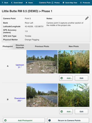
With photo point monitoring, users can capture photos at the same location over a period of time, providing a visual record of project site conditions.
Putting Data To Work
Back in the McKenzie River area, EWEB has successfully used the StreamBank tool to help define and visualize healthy riparian systems.
“With StreamBank, the metrics collected at reference sites are then compared with landowner [assessed] conditions, allowing landowners to see what constitutes a healthy riparian area and what actions they can take to increase the health of these critical areas,” said Karl Morgenstern, environmental management supervisor of EWEB.
EWEB has established a boundary identifying riparian forests and floodplains that are eligible to enroll in the VIP. Participation is open to private landowners, local governments, and non-profit organizations that own land within the designated boundary.
“The VIP is built on the concept of creating and sustaining protection and restoration activities at a meaningful scale and connecting upstream landowners with downstream water users,” said Morgenstern. “To that end, an integrated approach to managing our shared water resource is important.”
Additionally, the Metropolitan Wastewater Management Commission (MWMC) in Springfield, OR is beginning to use the data collected by EWEB and its partners for a complementary program in the same service area. Integration of these two water programs is increasing efficiency, because data does not have to be recollected by MWMC staff. It is also minimizing program costs, because site identification and prioritization have already been completed for the subbasin, and interested landowners have already been identified.
While EWEB is focusing on preserving healthy riparian areas, MWMC will focus on restoring the areas that lack healthy streamside vegetation. These combined efforts will allow maximized conservation and restoration outcomes for both source water protection and wastewater compliance.
The StreamBank toolkit can also be applied to other types of watershed restoration and protection programs. It can conduct GIS mapping of potential riparian restoration sites, prioritized according to ecological and economic criteria, for water quality trading programs geared toward temperature compliance for wastewater facilities.
It can model a “water budget” for the sustainable allocation of surface water and groundwater resources for uses, such as irrigation and municipal drinking water, using water-quantity and waterusage data. Finally, multi-stakeholder, cooperative source water protection program planning can be done based on conservation priorities as well as pollutant reductions.
Werling sees the big picture when it comes to all the field data generated by restoration actions. “Monitoring the success of restoration projects, sometimes more than 20 years for large trees, is a big deal,” she said. “It’s exciting for professionals and citizen scientists to use digital tools such as StreamBank to collect reliable data.”
Editor's Note: The following information regarding purchase of the app is from the FAQ section of The Freshwater Trust's website.
How can my organization use or purchase the StreamBank tools and app?
The Freshwater Trust uses its StreamBank methodologies and outputs to provide analytic services to partners to help them build watershed restoration programs. We continue to seek funding and refine the methodologies for our work, including our recent partnership with Google to expand the BasinScout methodology to make watershed analysis faster and more efficient. Additionally we have worked with a limited number of organizations to train them for beta testing the tools at their project sites. Please contact us if you are interested in piloting the tools with us for compliance or conservation projects.
About The Author
 Danielle Dumont is the Marketing Manager for The Freshwater Trust in Portland, OR. She brings nearly two decades of experience in corporate and marketing communications to The Freshwater Trust’s environmental consulting and watershed analysis services.