
Gravity Meets Groundwater Monitoring

By Kevin Westerling,
@KevinOnWater

Water reserves deep below the Earth’s surface can be seen from outer space, thanks to satellites, the law of gravity, and some smart people who connected the dots.
The diminishing supply of available freshwater is a reality that can be plainly seen all around us. Quite literally (depending on your location), you can go outside and see lakes and reservoirs drying up. Meanwhile, up in space, satellites help identify the scope of the problem by giving us a wider, more dramatic, viewpoint. But what about the status of our groundwater reserves? Here again, satellites are providing the answer.
While not necessarily new, the Gravity Recovery and Climate Experiment (GRACE) is continually providing new information. Launched 11 years ago as a joint project between NASA and the German Aerospace Center, GRACE utilizes the laws of gravity and the slightest of movements of two orbiting satellites to measure changing groundwater levels. Because water is so heavy, the mass loss it creates when depleted from an aquifer lessens the gravitational pull on the satellites, causing them to drift further into space. Orbit by orbit, the movements are tracked to create a picture of the changing groundwater environment.
GRACE researchers are now working with the World Resources Institute (WRI's) Aqueduct team to incorporate this new groundwater data into Aqueduct’s interactive water maps and global water risk assessment tool, which charts the escalation of groundwater depletion and water risk as it appears throughout the world. Community and business decision-makers can use this information to plan for the future, and to react to what’s currently happening just underfoot.
According to WRI, there has been almost no publicly available data to this point on how much water is within a given aquifer. Though there may be exceptions in accordance with local practices throughout the world, land owners generally withdraw groundwater without any metering or reporting, WRI states. There is little insight, therefore, into replenishment rates and sustainability.
These factors are of paramount importance to water-intensive industrial practices such as agriculture, which accounts for a whopping 70 percent of global water usage, according to the 2012 UN World Water Assessment. Meanwhile, WRI recently reported through some of its latest map data that 56 percent of irrigated agriculture is water-stressed.
Agriculture is just one of many industries represented on the interactive map, however. Use the dropdown menu under “Weighting Scheme” to filter on a variety of industries and water risk data (see below). The map also reveals information beyond just groundwater depletion — drought severity, flood occurrence, and regulatory and reputational risk are among the variety of water considerations charted and assessed.
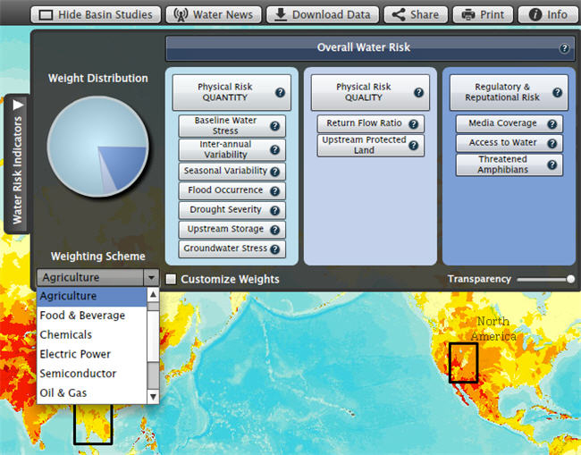
Credit: World Resources Institute
Still, the groundwater data is the most intriguing. Heretofore, it has been the missing puzzle piece — or at least a lost one. Thankfully, space-age technology in the form of (really) remote sensing has helped to complete the picture. If water is your business, or if your business relies on water, it might be a picture worth looking at.